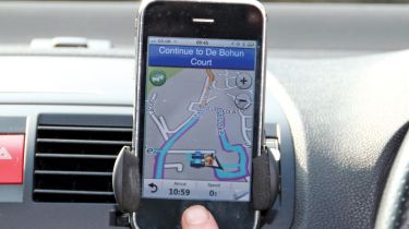
Garmin StreetPilot app
Navigation firm plays catch-up and launches its iPhone app

Price: £39.99
Contact: 023 8052 4000, www.garmin.com
Sat-nav market leader Garmin has found its way on to smartphones, with the new StreetPilot app with UK and Ireland maps.
Garmin users will be familiar with the clean and intuitive interface, but this app also introduces PhotoReal views for the first time, which bridge the gap between photos and 3D mapping.
They work well but for now are largely restricted to motorway junctions, which is a shame. Also, the 3D mapping could be more extensive.
Unlike rival TomTom, Garmin’s camera alerts are free. They’re updated every three minutes – or two if you buy the £2.99 per month (or £21.99 per year) live traffic service. These two functions also work if you haven’t set a destination, so the app is useful even when you know your route.
There are several options for setting a destination, including local Google searches and using the phone’s contact book. However, there are only two route types: fastest or shortest.
There are landscape and portrait views, the mapping is clear and the spoken instructions include street names. We also like the quick route preview and the way you can clear a destination by tapping the screen twice. StreetPilot is currently only available on iPhone, but an Android version is due later this year.
Verdict
Rating: ★★★★
What is it?
Paid turn-by-turn navigation iPhone app for motorists wanting an alternative to TomTom.
Problems?
PhotoReal junctions are currently limited, no in-app iPod control.
Why buy?
Easy Garmin interface, free safety camera database, undercuts main rival on price.


